¿Ha perdido la contraseña?
¿Nuevo usuario? Crear una cuenta
¡Disfrute y contribuya!
| Encontrar los mejores spots |
|
|
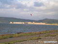
 Inverness
UK, Scotland
¡Este es un mapa interactivo! Use los controles para recorrerlo y hacer zoom.
|
Datum: WGS84 [ Ayuda ] |
Latitud: 57° 34.542' N |
Notación (0)
- Favoritos
-
Sus listas de spots favoritos y futuros
Acceso
|
Distancia de la ciudad En la ciudad Tiempo de acceso Acceso directo (< 5min) ¿Fácil de encontrar? Fácil de encontrar ¿Acceso publico? Acceso privado Acceso especial |
Características del spot de kitesurf
Nombre alternativo Ardersier
Calidad del spot Normal
Experiencia Intermediario
Tipo Playa
¿Kitesurf/viento? Bueno para Kitesurf
Estilo Freestyle, Freeride
Mejor momento
Peligros
Poblado durante la semana Repleto
Poblado en fines de semana Unos pocos kiters
Entorno
Calidad del agua Limpio
Corriente No sé
Fondo Arenoso
Marea Mejor en marea alta
Comodidades
Información adicional
Autor: yannick Colaboradores (1) ¡Ellos han navegado en este sitio! (0)
 Comentarios
Errores, opiniones.
Puede editar esta página para corregir los errores y añadir nueva información. Si tiene otros comentarios sobre esta página, Envíe sus observaciones
Por Anonymous , 27-03-2010
Fort George - This fort was built by the English after the battle of Culloden (1746) under the direction of the Duke of Cumberland. It was built (about 1780) primarily to subdue the Scots and keep them in check. It was named after a previous castle (in Inverness town) which was destroyed by the Jacobite's (the Scots) to stop the English using it.
It is the oldest fortification in the UK still being used by the British Army today. It covers some 42 acres and the interior is at or below sea level. The walls are up to 50 ft thick and have rooms built into them. It has never seen action in war. It is situated on the edge of the village of Ardersier about ten miles east of Inverness.